Wateresk Dolmen
Wateresk (Slidderyford) Dolmen: the “Shouldered” Portal Tomb of the Mournes
Why Wateresk is special
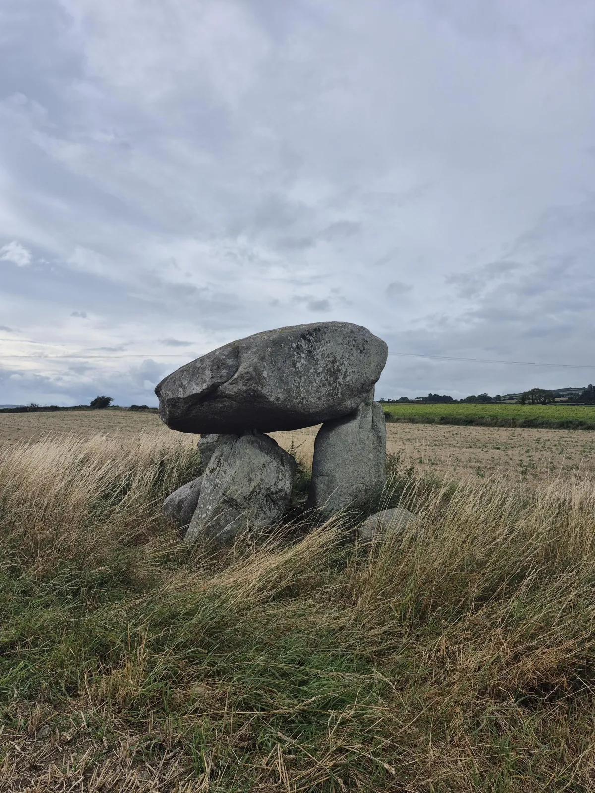
A few kilometres north of Newcastle, County Down, a granite capstone rests so neatly on its uprights that it looks held—cupped by a shallow concavity locals call a “shoulder.” This distinctive detail, seen on a handful of South Down megaliths, is especially striking at Wateresk and gives the tomb its sculptural feel. megalithicireland.com+1

What you’re looking at
Wateresk is a portal tomb (often called a dolmen): a heavy capstone supported by uprights at the entrance to a small chamber. Here the capstone is granite, about 3 m long and roughly 1 m thick, resting on three supports; the tallest upright is around 1.8 m. One of the portal stones shows the famed “shoulder” that cradles the capstone. irish megaliths website+1
Names, place & setting
You’ll hear two names: Wateresk Dolmen (from the local townland) and Slidderyford Dolmen (from the nearby crossing/bridge). The tomb sits just off the old Newcastle–Dundrum road near Slidderyford Bridge—nicknamed the “Twelve Arches.” Expect sweeping views toward Slieve Donard and the Mournes. megalithicireland.com+2themodernantiquarian.com+2
There’s also a beautiful older Irish place-name recorded in 19th-century survey material: Áth na gCloch Beó—“ford of the living stones,” often cited in modern summaries of the area’s toponymy. It’s a poetic fit for a monument that seems alive with balance and poise. Visions Of The Past
How old is it?
Portal tombs in Ireland belong to the Neolithic, broadly c. 4000–3000 BC. Wateresk hasn’t been directly dated, but the monument type places it comfortably in this period—long before Egypt’s Great Pyramid (c. 2560 BC). archaeopress.com
Was there a stone circle here?
Local antiquarian tradition says the dolmen once stood within a stone circle and that a loose boulder against the tomb could be one of the original circle stones. Treat this as unconfirmed tradition—part of the site’s storytelling rather than a verified feature today. Facebook+1
Visiting Wateresk (practical guide)
Where exactly is it?
Grid ref: J 3929 3441 (OSNI Discovery Map 36)
Coords: 54°14′22″ N, 5°51′47″ W (approx.)
Nearest town: Newcastle • Nearest village: Dundrum. megalithicireland.com+1
Directions (from Newcastle):
Take the A2 north for ~3 km. You’ll pass a small car park on the left; take the left immediately after, cross Slidderyford Bridge, and the dolmen is in a field on your left about 100 m after the bridge. megalithicireland.com
Access & etiquette:
The tomb often sits in a working field (crops/livestock). It is visible from the road, but access can be limited depending on the season. If the field is planted or stock is grazing, admire from the boundary and do not enter without permission. irishstones.org
Best light:
Morning or late afternoon when raking light accentuates the capstone’s edges and the portal-stone shoulder.
Safety note:
Roadside verges can be narrow—park responsibly and watch for traffic near the bridge.
Reading the stones on site
Circle the monument slowly. From one angle, the capstone feels impossibly heavy; from another, it looks effortlessly balanced. Step back to frame the Mournes behind it—this landscape relationship is part of the design language of many Neolithic monuments here. themodernantiquarian.com
Nearby ancient sites (easy add-ons)
If you’re making a day of it, consider: Ballynoe Stone Circle, Legananny Portal Tomb, or a Mourne ridge walk to the Slieve Donard cairns—each within a short drive. themodernantiquarian.com
Quick FAQ
Is Wateresk older than the pyramids?
As a Neolithic portal tomb, Wateresk’s type dates to c. 4000–3000 BC, which is older than the Great Pyramid (c. 2560 BC). Wateresk itself isn’t radiocarbon-dated, but the comparison is valid for the monument class. archaeopress.com
Where do I park and how close can I get?
There’s a small parking spot by Slidderyford Bridge; the tomb is ~50–100 m away in a field. Visibility from the road is often good; do not cross into crops or disturb stock. megalithicireland.com+1
Why is it also called Slidderyford?
It’s beside Slidderyford Bridge (“Twelve Arches”). Modern write-ups also reference an older Irish phrase Áth na gCloch Beó—“ford of the living stones”—linked to early survey records and local lore. Wikimedia Commons+1
Are there other stones nearby?
Yes—there’s a recorded standing stone a short walk away, and plenty of prehistoric sites across the Murlough/Donard landscape. themodernantiquarian.com
Credits and sources
Core on-site details, measurements and directions: Megalithic Ireland and Irish Megaliths; access notes from IrishStones; context and nearby sites from The Modern Antiquarian; inventory reference DOW 043:061 from the Prehistoric Burial Sites of NI. archaeopress.com+4megalithicireland.com+4irish megaliths website+4
If you enjoy field guides like this, watch our companion video on YouTube and subscribe to Standing Stones for weekly explorations of Ireland’s ancient monuments.